About FlyBy E6B
FlyBy E6B is an essential application for all pilots. Designed by a professional airline pilot it includes many features not found in the "other" E6B programs. If you are considering a career in aviation FlyBy E6B has...
FlyBy E6B is an essential application for all pilots. Designed by a professional airline pilot it includes many features not found in the "other" E6B programs.
If you are considering a career in aviation FlyBy E6B has functions that you can use in every aircraft you will fly.
FlyBy E6B was one of the very first applications of its kind published for the Palm Pilot. Used by thousands of pilots the world over, it has evolved from the suggestions and feedback we have received.
Please visit our web site for more detail and screen shots.
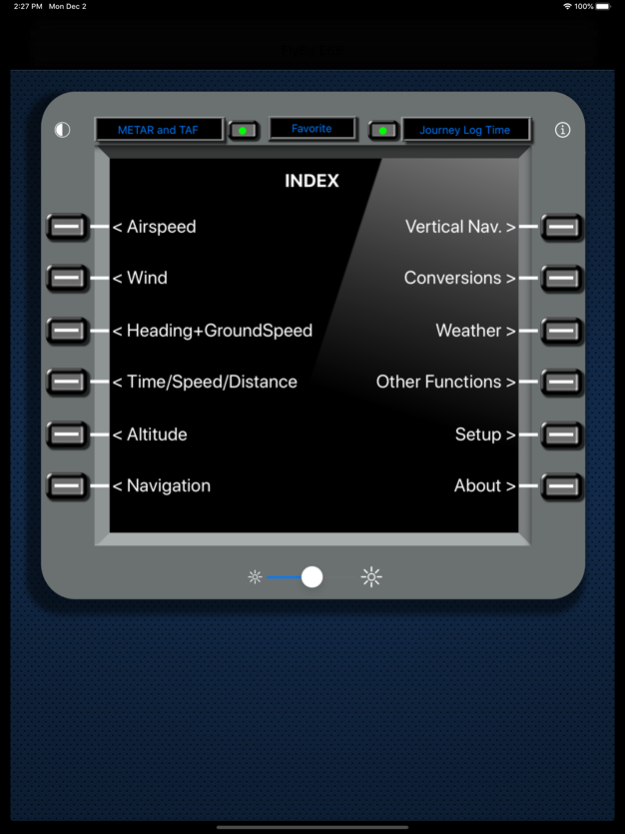
FlyBy E6B Features (70+):
Airspeed Calculations:
- True Airspeed using Calibrated Airspeed
- True Airspeed using Mach#
- Calibrated Airspeed using TAS
- IAS Using MACH#
- Equivalent Airspeed using CAS
- Mach# Using TAS
- Mach Crossover Altitude
- Planned MACH#
- Planned TAS
- Vref CAS
Wind Calculation:
- Find Wind Direction and Speed
- Find Wind Component (headwind and crosswind)
Heading and Ground Speed:
- Find Heading, Ground Speed, ETE and Fuel Burned
Time-Speed-Distance:
- Find Estimated Time Enroute
- Find Ground Speed
- Find Distance
- Find Fuel Time
- Find Fuel Flow
- Find Fuel Burned
- Find Estimated Time of Arrival
- Journey Log Time
- Time Adder
- Fixed GroundSpeed (Find a True Airspeed given a track, wind and required groundspeed)
Altitude Calculations:
- Density Altitude
- Pressure Altitude
- True Altitude
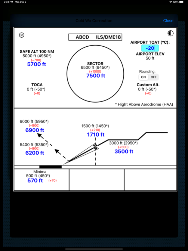
- Cold Temperature Altitude Correction
- China RVSM Airspace
- Device Altitude (If device has pressure sensor)
Vertical Navigation Calculations:
- Distance and Time using Altitude Change, Ground Speed, Vertical Speed
- Rate of Descent using Altitude Change, Ground Speed, Distance
- Rate of Descent using Altitude Change, Ground Speed, Descent Angle
- Feet/Nm using Vertical Speed, Ground Speed
- Feet/Nm (%) using Gradient %, Ground Speed
- Rate of Climb using Required Climb Gradient and Ground Speed
- SCDA (Constant Descent Angle)
- VDP (Visual Descent Point)
- VPA Deviation (Vertical Path Angle Deviation)
Navigation Calculations:
- Critical Point
- Equal Time Point
- Point of No Return
- Time to Minimum Descent Altitude
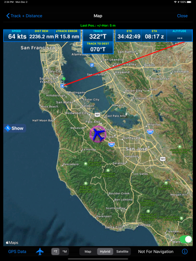
- Track and Distance between two points with map plotting of the great circle track. Map plotting includes movable pin locations with instant trip information: Distance, Track and time enroute.
- Map GPS mode. Displays device Speed, True Course, Altitude, Distance Remaining, Track to Destination, cross track error, estimated time remaining and estimated time of arrival.
- Map closest airport feature will display airports close to your current GPS location or a dropped pin location.
- Fix. Calculate a map point based on a Fix, Radial and Distance.
- Rate One Turn
- Radius of Turn
- Turning Stall Speed
- DME Arc distance and time
- VOR Nav
Conversions:
- Distance:
Nautical Miles/ Knots
Statute Miles/ Mph
Kilometers/ Kph
Feet
Meters
Meters/Second
Feet/Second
Feet/Minute
- Volume:
US Gallons
Imperial Gallons
Liters
- Temperature:
Celsius
Fahrenheit
Kelvin
- Weight:
Pounds
Kilograms
- Altimeter:
Inches Hg
Millibars/Hectopascals
mmHg
- Fuel, Temperature Corrected, JetA, JetB, AvGas:
US Gallons
Imperial Gallons
Liters
Pounds
Kilograms
- QFE/QNH airfield altitude conversion
- DMS/DM.m/DM.m and D.d coordinate conversion
- VNAV
Gradient%
Feet per NM
Angle
Weather:
- Relative Humidity, Heat Index, Cumulus cloud base, Wind Chill
- NOAA METAR and TAF access
- ISA Temperature Deviation
Other Functions:
- Linear Interpolation
- Minimum Floor Load Limit (Cargo)
- Maximum Cargo Weight
- Runway Slope
- PAX Weight
- C.G. Change
- Weight to Shift
- Distance to Shift
- Sunrise/Sunset: Civil Day/Night, Azimuth, Apex, Elevation, for any location and time/date. Includes a unique sunset ETA function that calculates your current flights sunset time.
Apr 4, 2024
Version 2024.12
- Fixed Pressure Sensor Permission setting. For iOS 17.4
Previous Versions
Here you can find the changelog of FlyBy E6B since it was posted on our website on 2016-10-31 07:33:03.
The latest version is 2024.12 and it was updated on 2024-04-19 19:44:16. See below the changes in each version.
FlyBy E6B version 2024.12
Updated At: 2024-04-04
Changes: Apr 4, 2024
Version 2024.12
- Fixed Pressure Sensor Permission setting. For iOS 17.4
FlyBy E6B version 2023.38
Updated At: 2023-10-20
Changes: Oct 20, 2023
Version 2023.38
- Fixed METAR/TAF NOAA data connection.
- Removed METAR/TAF Decoded option.
FlyBy E6B version 2023.37
Updated At: 2023-06-17
Changes: Jun 17, 2023
Version 2023.37
- Fixed Time Adder screen layout issue for smaller iPhones.
FlyBy E6B version 2023.3.6
Updated At: 2023-01-02
Changes: Jan 2, 2023
Version 2023.3.6
- Fixed iPhone Journey Log calendar button not working on iPhone 8.
- Adjusted Journey Log Time frames.
- Added Cancel button to calendar view.
FlyBy E6B version 3.14
Updated At: 2022-08-04
Changes: Aug 4, 2022 Version 3.14
- Fixed bug in Sunrise/Sunset/Route auto speed input.
- Increased Journey Log function iPad window size.
FlyBy E6B version 3.0
Updated At: 2021-12-08
Changes: Dec 8, 2021 Version 3.0
- iOS 15 update.
- Fixed Track and Distance map type selection out of view.
- Track and Distance Map minor layout changes.
- Fixed METAR and TAF crashing when not on secure internet connection.
FlyBy E6B version 2.99
Updated At: 2021-10-01
Changes: Oct 1, 2021 Version 2.99
- Bug fix for Journey Log Time function.
- Added empty row check to Journey Log Time. Will no longer automatically add another row if last row values are zero.
FlyBy E6B version 2.98
Updated At: 2021-09-25
Changes: Sep 25, 2021 Version 2.98
- Includes bug fix for Journey Log Time function.
Thanks again for your continued support!
FlyBy E6B version 2.97
Updated At: 2021-03-28
Changes: Mar 28, 2021 Version 2.97
- New function added: VOR Nav. Calculates a track and distance using two radial and DME points.
- Changed track label display in Track and Distance function.
FlyBy E6B version 2.95
Updated At: 2021-03-06
Changes: Mar 6, 2021 Version 2.95
Thanks for using FlyBy E6B.
Here is what you will find in our latest update:
- Journey Log Time Function improvements. You can now AirDrop, iMessage, Email or send to Notes App your days flying data.
- Added flight notes and date fields to Journey Log Time Function.
- Added "SPECI" to METAR if the observation is a special.
- Lots of under the hood code changes for iOS 14.